About LUNDAZI EXPLORATION PROJECT
Project Description
The license was granted on 21st August, 2024 to Unirate Investment's Limited after it had applied for the tenement. The area mapped by the Geological Survey of Zambia Department and compiled a Geological map at a scale of 1: 100000. The area lies in the Lufilian Arc, in which it has potential of hosting AMT, AQM, Au, Beryl, Co, Cu, EM,Fe, Pb, TML and Zn. The license area is located within Lundazi District, Eastern province, Zambia. It can be accessed via route T4 which runs from Lusaka to Chipata and has a total distance of approximately 573km after which join the M12 Chipata-lundazi road at about 73km. Branching off at Kawinga to Chikomene area.
Project History
FUTURE EXPLORATION ACTIVITIES
-Geological mapping -Soil Geochemical sampling -Magnetic survey to Identify structures that may control mineralization -Trenching over anomalous areas - Detailed mapping - Induced polarization - Drilling
Plan To Define the mineralization
OVERVIEW
The license area is situated within
Geology and location of the License area
OVERVIEW
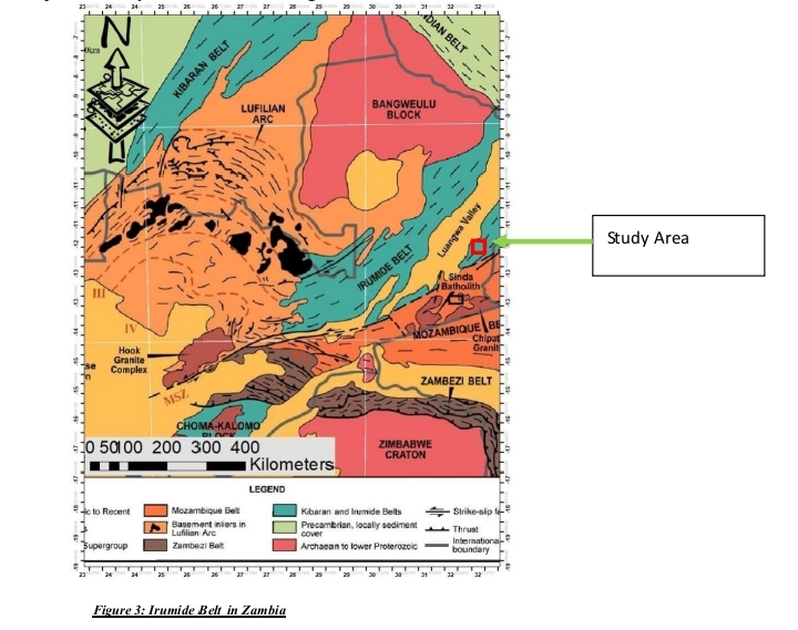
The license covers a land mass of 18025.2700 hector's, which was granted to Unirate Investment's Limited on 21st August, 2024. The license area from previous mapping has got mineralization include: Cu, Au, Lead, Talc and zinc around the area. The license holder has interest in AMT, AQM, Au, Be3Al2(SiO3)6, Co, Cu, EM , Fe, Mn, Lead and zinc. The license area and it's environs, lies south of the Irumide belt which is also South East of Lundazi, Chikomene area. It falls within the basement complex and MesoProterozoic rocks. Mineralization types in irumide belt of eastern Zambia include: magmatic, Volcanogenic, Hydrothermal, pegmatitic and placer deposits. Different Rock types were various mineral deposits occur within irumide belt include: paragneisses and Amphibolites( Zn, Cu), schist and meta volcanics (Au, Cu, Garnet), paragneisses and Granulites (C, Garnet). The area is the Brown field in which work data was accessed during desk study from ZCCM-IH and also from Geological Survey Department of Zambia, from mining Cadastre office
Geology and location of the License area
Gallery